An Ice Dam Collapsed
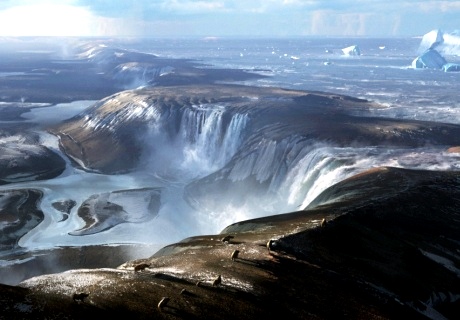
Rock-Ice land bridge and glacial Lake, artist concept (credit: ICL)
In what must have been one of the most dramatic geological events ever, a glacial lake burst through a land-bridge consisting of chalk, rock, and ice in prehistoric Europe. The resulting cataracts carved the oceanic gap that now exists between Britain and France. Remnants of the dam's existence have been uncovered by the Earth Sciences Department at Imperial College of London. Their research determined that a series of events began at the end of an ice age 450,000 years ago creating the English Channel when the dam finally failed and a massive lake behind it burst through. It would have been quite the impressive sight to safely behold.
Initially, waterfalls draining from the ice-dammed lake, created by meltwater off a receding icecap as well as rivers flowing in northern Europe, breached a ridge line at the Dover Straits. The combination of high water volumes and extreme pressure produced episodes of mass erosion. Measurements of the present-day seafloor revealed sediment-filled depressions incised deeply into the bedrock. They were interpreted as giant 'plunge pools' created by these gigantic cascades. The depressions offered an initial model for the erosion of the Dover Strait by this spillover, with plunge pool erosion, and subsequent dam breach by mega-floods in a 2-step process. According to the research announcement:
"previously, our researchers revealed geophysical evidence of giant valleys on the seafloor in the central part of English Channel. They believed these valley networks were evidence of a mega-flood gouging out the land, which they speculated may have been caused by a catastrophic breach in a chalk-rock ridge joining Britain to France. Working with colleagues in Europe, they have now shown the details of how this chalk ridge in the Dover Strait was breached. New geophysical data from Belgium and France has been combined with seafloor data from the UK showing evidence of huge holes and a valley system located on the seafloor. Cross-cutting of the submerged landforms by a prominent eroded valley, characterized by features that are typically associated with catastrophic flooding, indicate the final opening of the Strait by high-magnitude floodings."
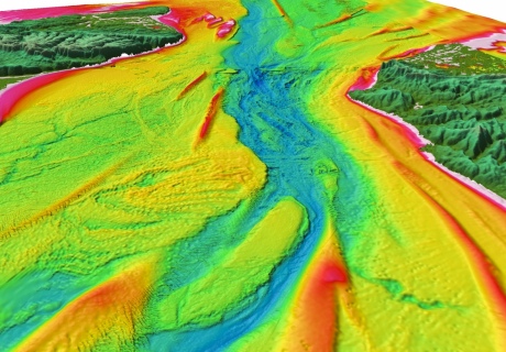
Pre-English Channel ice-land bridge, cataracts, and plunge pools with flooding map after collapse (credit: ICL)
One of the lead investigators noted:
"Based on the evidence that we’ve seen, we believe the Dover Strait 450,000 years ago would have been a huge rock ridge made of chalk joining Britain to France, looking more like the frozen tundra in Siberia than the green environment we know today."
An explanation of the pre-channel, tundra environment, was included with the report. The complete study is available here. WHB