Field Work
Field Researchers Diversity (credit: JPL/CalTech)
When you think about 'field research' at the Jet Propulsion Laboratory in California it typically conjures images of robots on Mars, cameras focused on Jupiter or Pluto, or landers sampling Titan's hydrocarbon atmosphere. But at the Lab itself, field work takes many forms and teams collaborate with many other researchers elsewhere often in environments more terrestrial and space.
Unknown to many, JPL is applying its remarkable engineering and scientific talents to collaborate with environmental investigators on Earth. The collaborations are accelerating our understanding of how ecosystems function from the arctic to the tropics, into the atmosphere, and down into the ocean's depths. Researchers worldwide now use JPL's gathered data, often combined with satellite observations, imagery, and computer models, to tackle challenges in understanding how the Earth's environments interact to form an integrated ecological system.
Several projects at the Lab include: a technology mission over Hawai'i and the Western Pacific to collect airborne data on the health of coral reefs that will be combined with a future satellite mission to study reefs worldwide; a mission for a month-long survey across the Pacific to monitor the diversity of microscopic phytoplankton essential for oxygen production and their impact on the marine carbon cycle; and a winter airborne campaign over Colorado's forests to provide the first multiyear monitoring of how much water is stored in its snow-covered mountains.
JPL's long-running project the Coral Reef Airborne Laboratory (COral) helps to assess the condition of reef ecosystems in Palau, Guam, and the Marianas. COral been being expanded to collaborate with the elite marine biologists at James Cooke University in Queensland who have been mapping the Great Barrier Reef in Australia at sea level. This combined science, aerial mapping, and reef status survey efforts have greatly accelerated the capacity of the marine ecologists to understand, and potentially restore, damaged sections due to ocean heatwaves, a result of climate change.
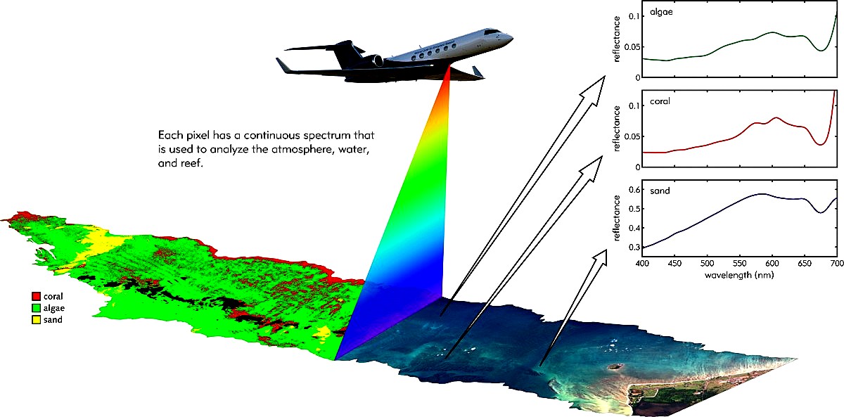
Radar scans, Hawai'i, Western Pacific reefs, coral (red); algae (green); sand (yellow) (credit: JPL/CORAL/CalTech program)
The Earth's ecosystems by their very nature are complex and require 'big data' sets from multiple investigators and disciplines to properly analyze. Field studies in ecology, geochemisty, marine biology, and underwater mapping are all benefiting from these collaborations with JPL's space scientists and engineers. Everyone is learning from the knowledge shared about our living environment. JPL's airborne reef surveys are an initial inter-disclipinery step. Maybe someday such collaborations will be followed by a satellite dedicated to help restore once coral covered regions now degraded or lost. WHB