Hemispheric Weather Extremes
Australian extreme temperature anomalies, Jan, 14-28, 2019 (credit: Terra satellite)
Extremes temperatures are occurring in both hemispheres at once. While North America is experiencing some of the coldest days this northern winter, Australia is suffering through the highest temperatures ever recording for their mid-summer season.
NASA's environmental monitoring Terra satellite has measured the extreme heat affecting most of Australia including the far southern state of Tasmania. Surface temperature anomalies were gathered in mid-January, mapped, and then compared to similar two-week periods from 2000-2012. Reds depict areas hotter than average while blues represent colder. White areas show normal temperatures with gray zones represent missing data, likely due to cloud cover.
According to NASA and Australia's Bureau of Meteorology (BOM), the summer of 2018-19 has brought seven of the ten hottest days on record. The most extreme heatwave occurred over consecutive days, when the averaged temperatures exceeded 104°F (40°C). January 15th ranked as the second-hottest day ever in Australia, less than one degree short of that nations all-time record set in January 2013. Adelaide, the capital of South Australia, recorded its hottest temperature for any state capital in 80 years, reaching 116°F (46.4°C), January 25th. With such heat extremes, forest fires ignited in Tasmania, Australia's cool island famous for temperate rainforests, in Eucalyptus trees rich in volatile oils.
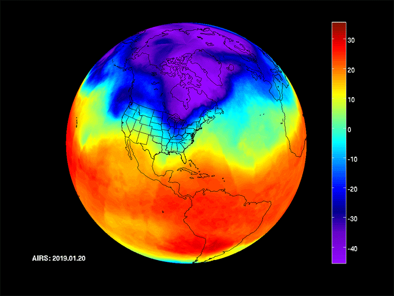
Polar Vortex Data Visualization, Jan. 20-29, 2019 (credit: JPL)
In the northern hemisphere, dangerously cold temperatures have affected the Mid-western US and Canada during the time as in Australia. Researchers at JPL in Pasadena captured continuous imagery of the polar vortex forcing upper atmospheric temperatures to plunge deeply south. Using data from an infrared sensor carried on NASA's Aqua satellite, the Arctic vortex has moved from central Canada into the Midwestern states between January 20-29th. The lowest temperatures are purple and blue and range from -10F to -40F below average. The data animation, shows the coldest areas as the air mass plunges south.
At both poler regions, changes in their jet streams, most likely caused by oceanic and atmospheric temperature increases due to climate change, have affected typical weather patterns. Climate research is underway at many institutions, such as Woods Hole Oceanographic Institution, to determine to what extent the warming atmosphere is amplifying extreme weather events.
Climate research is a long process while people in Australia and the US are suffering from immediate, and extreme, weather now.
WHB