Climate Resilience Mapping
USA climate change resilience scores mapped by county, blues higher, tans lower (credit: EPA)
With little fanfare, the Environmental Protection Agency (EPA) released results of a multi-year study: Development of a Climate Resilience Screening Index. In their comprehensive and statistical analysis, the Agency investigated US counties nationwide for their resilience to climate change. The results provide important insight on which regions are the most or least prepared to deal with the issue. Some counties are equipped to handle the changing situation much better than others.
In their Executive Summary the EPA notes:
"there is a recognition across the nation of the benefits in creating environments resilient to adverse climate events. The challenge for communities is to find ways to preserve the socio-ecological systems they depend upon in the face of changing natural hazard threats."
Environmental risk factors such as increasing temperature and droughts; severe weather like hurricanes and tornadoes; and flooding from rising sea levels were considered in the EPA's analysis. Social issues including inequality, ethnicity, and existing infrastructure were also evaluated. The summary map shows states in the central Great Plains of Texas, Kansas, through the Dakotas; the Appalachian region; and the Southeastern USA that may not be well prepared to handle existing or the expected environmental changes underway.
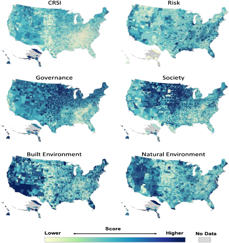
Resilience Maps, scores by risk, governance, society, infrastructure, & natural environment (credit: EPA)
The Agency considered resilience to be a function of several social issues including the society, building infrastructures, hazard risks, governance, and natural features like topography. Nearly 120 separate big-data sets, applying these parameters, were gathered and quantitatively analyzed by the EPA scientists as they developed their maps` Some US cities and counties are already developing resiliency implementation plans.
Many resilience efforts will be required to deal with the specific circumstances of the diverse counties and regions in the US. Practical and efficient solutions will offer opportunities for creativity to moderate the effects of climate change. The EPA's report effort is an important start. The entire EPA resilience mapping document with its data and related analysis is available here.
WHB