Animating Ice Data
Palmer Land and the Antarctic Peninsula Map (credit: Wiki-commons)
When long-term, continuous, sets of ice measurements exist, the best way to visualize any changes is to animate the data.
NASA and the European Space Agency (ESA) have been studying ice flows on Greenland and Antarctica for nearly three decades using satellite radar and ice models. Radar is well suited for monitoring environmental changes in the polar regions which are prone to bad weather and long periods of darkness. Remote sensing scanners can gather the required data and other information regardless those conditions, clouds, or time of day. A description of some of the ongoing ice research was summarized in a NASA produced video.
Additionally, the European Space Agency (ESA) has been gathering ice data from the Antarctic Peninsula with their Envisat and Copernicus Sentinel-1 satellite missions. Glaciers on the peninsula have been measured to move up to 11 inches/day in some locations or the equivalent of an average 13% increase in flow speeds across the study area. Ice flows in Palmer Land increased an average of 13% with blue indicating slower movement and red zones faster over the satellite surveyed area.
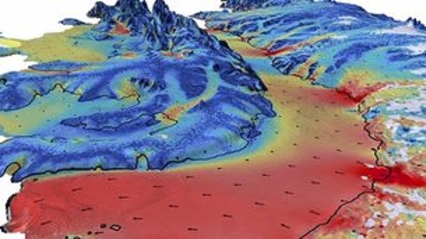
Palmer Land ice flow increases (credit: Sentinel-1)
Satellite data was combined with an ice-flow model to fill-in the gaps where data was unavailable. This approach allowed an estimate that the glaciers’ speed had increased the discharge of 3.5 cubic miles of ice/year into the surrounding Antarctic Ocean. The European agency noted that:
“circumpolar deep water, is relatively warm and salty compared to other parts of the Southern Ocean, has warmed in recent decades, and can melt ice at the base of glaciers which reduces friction and allows them to flow more freely. With much of Western Palmer Land’s ice mass lying below sea level it is important to monitor how remote areas such as this are responding to further warming in the region due to climate change."
It is likely that even faster ice-flows and melt water being discharged from both Greenland and Antarctica in the coming years. WHB