Canyoneering in Antarctica
LiDAR equipped Twin Otter in Antarctica (credit: PolarGap, ESA/BAS)
Canyoneering is an extreme sport of exploration. It doesn't get more extreme than in Antarctica where the discovery of a under-ice canyon system exists under the icecap. The British Antarctic Survey (BAS) and colleagues at Northumbria University in the UK, undertook research with the European Space Agency's PolarGap satellite survey of the polar continent. Their results revealed a vast series of canyons that were hinted to exist from some previous research.
According to the announcement, PolarGAP is an ambitious international mission to capture critical data about the Earth’s gravity field using ESA's radar systems and LiDAR technologies. They are deployed on Twin Otter aircraft to fill a ‘data gap’ in elevation measurements over the South Pole. The ESA's Earth observing satellites (GOCE and CryoSat 2) allow the ability to ‘map’ the Earth’s gravity and monitor how the Earth’s ice fields are responding to environmental change.
Publishing in Geophysical Research Letters the British researchers noted the:
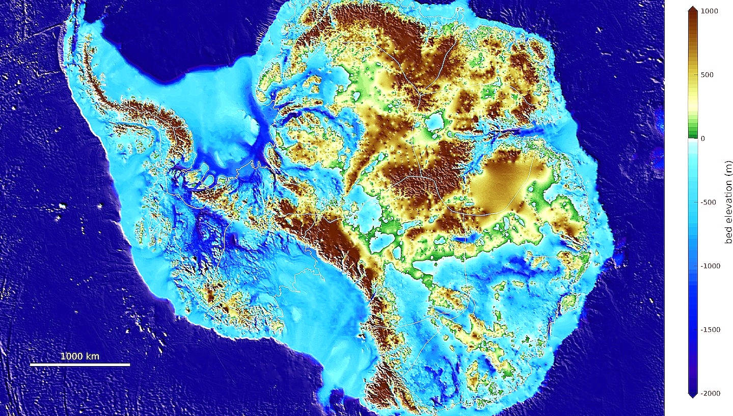
collected radar data enabled mapping of the bedrock hidden beneath the ice. The data revealed the topography controls how quickly the ice flows between the East and West Antarctic ice sheets. The team mapped for the first time three vast, subglacial valleys in West Antarctica. These valleys could be important in the future as they help to channel the ice flowing from the center of the continent towards the coast. If climate change causes the ice sheet to thin, these troughs could increase the speed at which ice flows from the centre of Antarctica to the sea, raising global sea levels.
Sub-glacial canyon system, Antarctica (credit: BAS)
The investigators have named the largest valley, Foundation Trough. The canyon is more than 200 miles long, deeper than the Grand Canyon, and covered by nearly two miles of ice. The three valleys function like watersheds where ice flows towards the Ross Sea to the west and Weddell Sea in the east. A sub-glacial lake was also discovered that may have existed since Antarctica was ice free.
Sub-ice Radar Map, Foundation Trough, Antarctica (credit: BAS)
Researchers at Durham University, also in the UK, had reviewing earlier data hinted towards a discovery of the newly mapped canyon system. It will be very important to watch what happens in these canyons as climate change continues to affect the southernmost continent.
WHB