Surging Storms
Hurricane Irma weather measurement maps, 9-7-2017 (credit: NOAA GEOS-16)
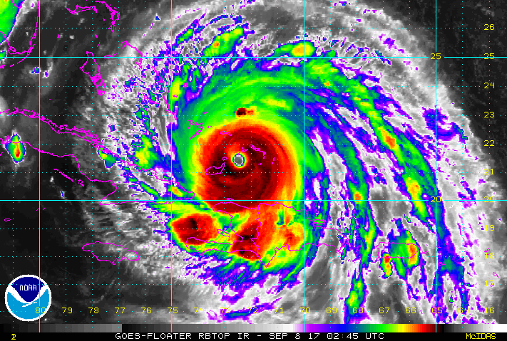
Two and perhaps three hurricanes are moving in the Atlantic Ocean towards Caribbean islands, Mexico, and the USA. The new "workhorse" of weather forecasting, the GEOS-16 weather satellite became operational in Fall 2016 and is following their development. GEOS-16 has already produced remarkable imagery and copious scientific measurements of the storms using its 16-channel environmental sensors that detect wind speeds, moisture content, temperatures, etc.
The monster storms that have already destroyed entire islands including Saint Martin and Barbuda as well as heavily damaging the US Virgin Islands. The American Geophysical Union (AGU) has closely followed Irma and provided background information for people living in the path of this super-storm as it approaches the Florida. According to the organization:
if you're not in Hurricane Irma's eyewall, you're not in the real hurricane; winds will be noticeably less a few miles inland due to friction; highest winds will be directly in the eyewall; where Irma makes landfall, eyewall winds will go well above hurricane force; storm surges will be highest if the eye is just inland from the coast and high tide zone; high tide will be 3 feet higher above sea level in Miami on Sunday adding more water on top of storm surges and the waves; rainfalls will be lower than Hurricane Harvey as Irma will keep moving.
A NOAA animation produced by the National Weather Service illustrates how much destruction storm surges can produce and why:
As more super-storm data is gathered by Earth monitoring satellites like GEOS and ocean-based temperature bouys, climate models and prediction will become ever more accurate. So far, all models continue predicting that amplitude, intensity, and frequency of extreme weather events will increase due to atmospheric alterations from climate change. The atmosphere drives the world's climate system and Irma is no exception, just made more extreme.
WHB